Need product customization?
We can customize PROTEUS-UHD to better suit your requirements


Video Overlay technology allows text and images to be layered over live video, producing visuals that appear naturally embedded in the scene while preserving a clear view of the original environment.
PROTEUS-UHD is designed for overlaying text, images and data onto 2K and 4K live video. This capability is ideal for applications such as broadcasting, surveillance, mapping, and real-time monitoring—where overlays provide critical contextual information.
With four independent 4K UHD (3840 × 2160) OSD layers, PROTEUS-UHD allows precise composition of sensor data, text, and PNG images with pixel-level control over position, color, alpha-blending, and brightness.
PROTEUS-UHD supports any Windows font with full anti-aliasing (subpixel rendering) to ensure smooth, high-quality text rendering. It includes a set of built-in fonts and allows an unlimited number of additional fonts to be loaded.
While PROTEUS-UHD offers advanced functionality through additional widgets3, (i.e. ROV situation awareness, sliders, gauges, compass, up/down timer, counters, etc.), its core strength lies in efficient handling of text, image, and geospatial data overlays.
PROTEUS-UHD ensures compatibility with modern high-resolution, high-bandwidth video systems. Its ability to operate independently of a host computer simplifies deployment and enhances reliability for standalone applications.
PROTEUS-UHD comes with two companion Apps:
To Download Our Brochure & Manuals, Click Here.
| General Features |
|---|
| Full Ultra High Definition Video Overlay |
| Stand-alone operation i.e. no PC required |
| Windows based app ProteusWizard for designing your OSD |
| Windows based app ProteusApp for simulating sensor data and practicing drawing commands via RS232 or ethernet |
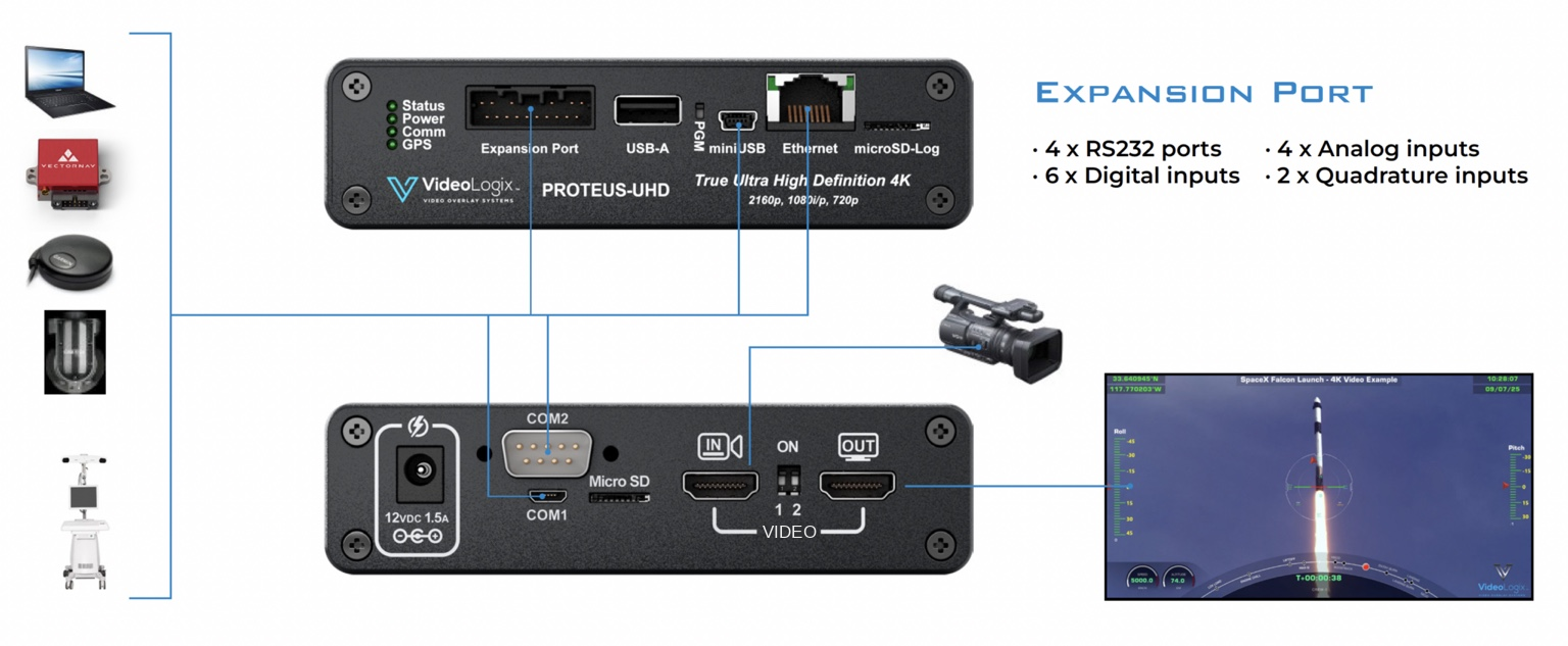
| Overlay data from any GPS modem ($GPRMC, $GPGGA, $PTSAG, etc.) |
| Overlay data from any NMEA 0183 strings ($GPWPL, $SDDPT, $SDDBT, $WIMTW, $WIMWV, $VNINS, $VNIMU, $VNYPR, etc.) |
| Overlay data from any CSV strings received via RS-232, USB, Ethernet |
| Supports unlimited number of Windows fonts with full anti-aliasing (subpixel rendering) to ensure smooth, high-quality text rendering |
| Four independent 4K UHD (3840 × 2160) OSD layers allow precise composition of sensor data, text, and PNG images with pixel-level control over position, color, alpha-blending and brightness |
| Accepts over a dozen drawing commands via RS-232, Ethernet or USB, allowing easy interface with laptops, Crestron, etc. |
| Built-in Compass and Tilt (Pitch & Roll) sensors |
| Battery backed up real time clock (RTC) |
| Video |
| 2160p @ 23.97, 24, 25, 29.97, 30, 50, 59.94, 60 Hz |
| 1080i @ 50, 59.94, 60 Hz |
| 1080p @ 23.98, 24, 25, 29.97, 50, 59.94, 60 Hz |
| 720p @ 50, 59.94, 60 Hz |
| Fast video input to output delay |
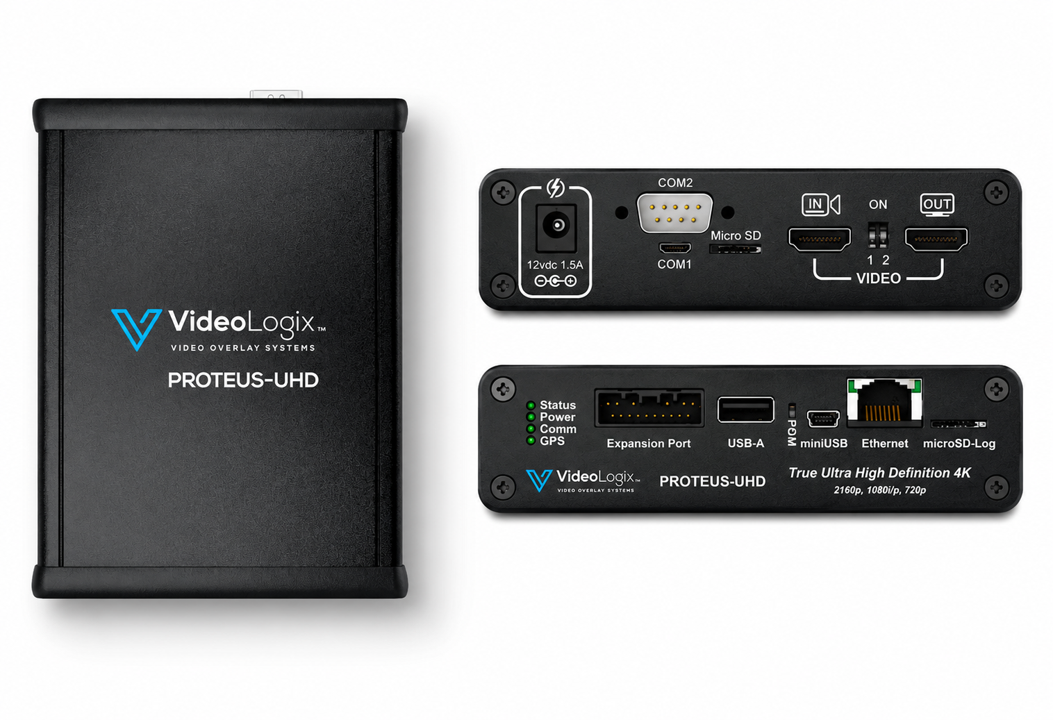
| Ports |
| 4 x RS232 |
| 1 x CAN interface |
| 1 x Micro USB Device |
| 1 x Ethernet 10/100 (Static or DHCP IPv4 addressing) |
| 1 x IRIG-B |
| 5 x GPIs 4, each capable of controlling the ON/OFF state of any graphic widget or triggering and controlling the count up/down timers |
| Additional Features |
| Analog Inputs: Convert analog inputs to speed, depth, pressure… 2 |
| Quadrature Inputs: Convert count to distance, speed… |
| Supported Devices: VectorNav INS, GPS sensors, any sensor with CSV string output |
| Built-in Widgets: ROV & Aerial situation awareness, Compass, Slider, Count up/down timer |
| Others |
| Box Dimensions (mm) 167 x 129 x 34 |
| Weight (525 grams) |
| Power (12V DC, 1.5A via 2.1mm x 5.5mm jack) |
| 2-year warranty |
| Recommended Operating Temperature Range: 10-40°C |
We can customize PROTEUS-UHD to better suit your requirements